


Pine Ridge Voting District, Adams County, Mississippi
About
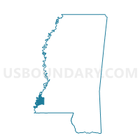
Outline

Summary
| Unique Area Identifier | 605044 |
| Name | Pine Ridge Voting District |
| County | Adams County |
| State | Mississippi |
| Area (square miles) | 41.88 |
| Land Area (square miles) | 38.44 |
| Water Area (square miles) | 3.44 |
| % of Land Area | 91.78 |
| % of Water Area | 8.22 |
| Latitude of the Internal Point | 31.67249920 |
| Longtitude of the Internal Point | -91.35043010 |
Maps


Graphs
Select a template below for downloading or customizing gragh for Pine Ridge Voting District, Adams County, Mississippi


Neighbors
Neighoring Voting District (by Name) Neighboring Voting District on the Map
- Airport Voting District, Adams County, MS
- Church Hill Voting District, Jefferson County, MS
- Foster Mound Voting District, Adams County, MS
- Northside School Voting District, Adams County, MS
- Precinct 1-3, Concordia Parish, LA
- Precinct 15, Tensas Parish, LA
- Thompson Voting District, Adams County, MS
Top 10 Neighboring County Subdivision (by Population) Neighboring County Subdivision on the Map
- District 5, Adams County, MS (7,957)
- District 4, Adams County, MS (5,408)
- District 1, Concordia Parish, LA (4,201)
- District 4, Jefferson County, MS (731)
- District 6, Tensas Parish, LA (651)
Top 10 Neighboring Unified School District (by Population) Neighboring Unified School District on the Map
- Natchez-Adams School District, MS (32,297)
- Concordia Parish School District, LA (20,822)
- Jefferson County School District, MS (7,726)
- Tensas Parish School District, LA (5,252)
Top 10 Neighboring State Legislative District Lower Chamber (by Population) Neighboring State Legislative District Lower Chamber on the Map
Top 10 Neighboring State Legislative District Upper Chamber (by Population) Neighboring State Legislative District Upper Chamber on the Map
- State Senate District 32, LA (111,685)
- State Senate District 34, LA (101,227)
- State Senate District 37, MS (55,722)
- State Senate District 38, MS (52,716)
- State Senate District 36, MS (50,974)
Top 10 Neighboring 111th Congressional District (by Population) Neighboring 111th Congressional District on the Map
- Congressional District 3, MS (756,924)
- Congressional District 2, MS (668,263)
- Congressional District 5, LA (644,296)
Top 10 Neighboring Census Tract (by Population) Neighboring Census Tract on the Map
- Census Tract 9501, Jefferson County, MS (6,162)
- Census Tract 2, Adams County, MS (4,126)
- Census Tract 1, Concordia Parish, LA (2,538)
- Census Tract 3, Tensas Parish, LA (2,163)